Construction Drones in Japan: What Sites Use Them For, and the Rules
The short version
- Drones are an ordinary tool here: progress photos, earthwork surveys, roof and high-place checks, safety planning.
- Survey flights become a 3D model of the ground, used for earthwork volumes and to feed the machines.
- Japan’s rules start at 100 g, not 250 g. Register the aircraft, fit Remote ID, and check the airspace before you fly.
- i-Construction 2.0 targets saving at least 30% of the labour, or 1.5 times the productivity, by fiscal year 2040.
Hi there, I’m Shirokuma!
A few years ago, I watched a drone I had just bought get pushed sideways by a light breeze, drift over the fence, and land on the roof of the factory next door. That was the day I learned that flying a drone on a construction site is not quite as easy as it looks.
These days, drones are a normal tool on Japanese job sites. They take progress photos, measure how much soil has been moved, and check roofs that used to need scaffolding.
In this guide to construction drones in Japan, you’ll learn:
- What we actually use drones for on Japanese job sites
- How Japan’s drone rules work, in plain English
- How to check, on a free map, whether you need permission to fly somewhere
I’m in my 12th year in Japanese construction. I worked with drones during my site supervisor days, and I hold a Class 3 Multirotor Drone Pilot certification from DPA, a drone pilot association here in Japan. So I’ll share both the useful parts and the mistakes I made.
What Construction Drones Actually Do on Site
Before we get to the rules, let’s look at why sites want drones in the first place. Here’s what I’ve seen them used for.
Progress photos
A photo from 50 meters up shows the whole site in one frame. That’s hard to beat when you’re reporting to the client each month, or when someone who can’t visit the site needs to see how things are going.
Surveying earthwork
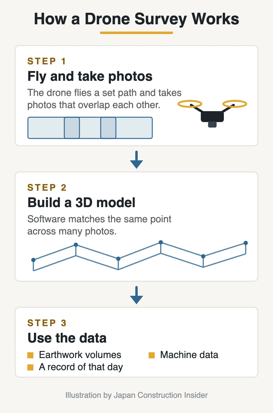
This is the big one. A drone flies a set path, takes overlapping photos, and software turns them into a 3D model of the ground. From that, you can work out how much soil has been cut or filled. We’ll look at how this works in the next chapter.
Checking high places
Roofs, the tops of steel frames, the outside of tall walls. Sending a drone up takes minutes. Putting up scaffolding, or lifting someone in a basket, takes much longer — and puts a person at height.
Safety and planning
An overhead view makes it easy to see how trucks move in and out, where materials are piling up, and where the site is getting crowded. Things you don’t always notice from the ground.
Completion photos
When the job is done, an aerial photo of the finished building is a nice record — for the client, and honestly, for the team too.
One thing I want to be clear about: a drone doesn’t replace anyone. It saves the trip up a ladder, and it gets you a picture you couldn’t get otherwise. Someone still has to fly it, and someone still has to decide what the photos mean.
Drone Surveying: From Photos to a 3D Model
How it works
Drone surveying sounds complicated, but the idea is simple. It’s the same trick your eyes use to judge distance: look at the same thing from two places, and you can tell how far away it is.
- The drone flies a planned path over the site, taking photos that overlap each other.
- Software compares the same point across many photos and works out its position in space.
- The result is a 3D model of the ground, and a point cloud — a huge set of measured points.
Before the flight, the crew usually places markers on the ground and measures their exact positions. These reference points tell the software where the model sits in the real world.
What you get from it
Once you have the 3D ground surface, a few useful things follow.
- Earthwork volumes. Compare today’s ground surface with the design, or with last month’s survey, and you can see how much soil has been cut or filled.
- A record that doesn’t fade. The site as it was on that day, in a form anyone can look at again later.
- Data for the machines. The design surface can be loaded into an excavator or bulldozer fitted with machine guidance, which shows the operator exactly where the blade should be.
Why Japan is pushing this
There’s a national program behind a lot of this. Japan’s Ministry of Land, Infrastructure, Transport and Tourism (MLIT) runs an initiative called i-Construction, which brings digital tools into public works — 3D surveying, data that flows from design to the machines, and so on.
In April 2024, MLIT published the next step, i-Construction 2.0, aimed at automating construction sites. Its stated target is to save at least 30% of the labor, or improve productivity by 1.5 times, by fiscal year 2040.
Source: MLIT, “i-Construction 2.0” (April 2024) (PDF, in Japanese)
The reason is the same one I wrote about in my first article: there are fewer workers joining the industry, so the work has to get done with fewer hands.
How often does a drone fly?
It depends on the site.
On a large site, flying often makes sense: the layout changes every day, and one photo from above can’t be replaced by walking around. I’ve heard from someone who worked on the 2025 Osaka-Kansai Expo construction that a drone went up and filmed the site every single day. That’s secondhand — I wasn’t there myself — but on a site that big, it makes sense to me.
On a smaller site, you don’t need that. You can see the whole thing from the ground, or from the top floor, so a monthly flight for progress photos is often enough.
Flights that run themselves
Here’s the part I find interesting. Some sites now use drones that are set to fly on a schedule — the same route, from the same spot, at the same time each day, with no one holding a controller. The drone takes off, flies its path, takes the photos, and comes back.
That gives you something valuable: the same view, day after day, so you can put the images side by side and see exactly what changed.
I wouldn’t be surprised if this becomes normal equipment on sites in the future — a drone that starts by itself every morning and takes the same shots, the way a security camera just sits there and does its job.
I should be honest about one thing, though. On the building sites I worked on, drone surveying wasn’t an everyday event — it suits earthwork and civil engineering jobs more than a hospital or a factory building. But the direction is clear, and the tools keep getting easier to use.
Japan’s Drone Rules in Plain English
If you’re used to flying in the US or Europe, the first thing to know is that Japan’s rules start at a much smaller drone.
Step 1: Register the aircraft
In Japan, any drone weighing 100 g or more must be registered before it flies outdoors. That’s a lower bar than many countries — the US, EU, UK, Canada, and Australia all start at 250 g — so a drone that needs no paperwork at home may need it here.
Registration became mandatory on June 20, 2022. You register through an online system called DIPS, put the registration ID on the airframe, and fit the drone with Remote ID, a small function that broadcasts the aircraft’s ID by radio while it flies.
Flying an unregistered drone is not a small matter: the penalty is a fine of up to 500,000 yen, or up to one year in prison.
Source: MLIT, Unmanned Aircraft Registration Portal
Step 2: Check the airspace
Some airspace needs permission from the government before you fly:
- Airspace around airports
- Airspace 150 m or higher above the ground
- Airspace over densely inhabited districts (DID) — the crowded areas of cities and towns
Most construction sites in a city center sit inside a DID, so on those jobs, permission comes first. I’ll show you how to check this on a free map in the next chapter.
Step 3: Check how you plan to fly
This is the part people miss. Even in airspace that needs no permission, there are rules about how you fly. Without separate approval, you must:
- Fly in the daytime
- Keep the drone in sight with your own eyes
- Keep 30 m or more away from people and property that aren’t part of the operation
- Not fly over event venues with crowds
- Not carry hazardous materials
- Not drop objects from the aircraft
On a job site, the 30 m rule is the one that catches people out. A site is full of people, vehicles, and buildings, so in practice you often need approval for that, too.
Source: MLIT, Flight Rules for Unmanned Aircraft
Step 4: Licenses (and when you need one)
Japan introduced national pilot certificates on December 5, 2022: Class 1 and Class 2. Here’s the part that surprises people: for most work, a license is not required. You can apply for permission for a specific flight without one.
What a license does is make things simpler. It can remove some paperwork, and Class 1 is what allows the most difficult category of flight — flying beyond your line of sight over populated areas, which Japan calls “Level 4.”
There are also private certifications, like the DPA course I took. They aren’t the national license, but the training gets you flying safely, and some of them shorten the national exam process.
How to Check Where You Can Fly (GSI Maps)
Here’s the practical part. Japan’s government publishes a free map that shows the airspace you need permission for. It’s run by the Geospatial Information Authority of Japan (GSI), and MLIT links to it from its own drone page.
Open the map: GSI Maps with the drone layers turned on
That link already has the two layers you need switched on, and the place names set to English. (The buttons around the map are in Japanese, but you won’t need them for this.)
Reading the colors
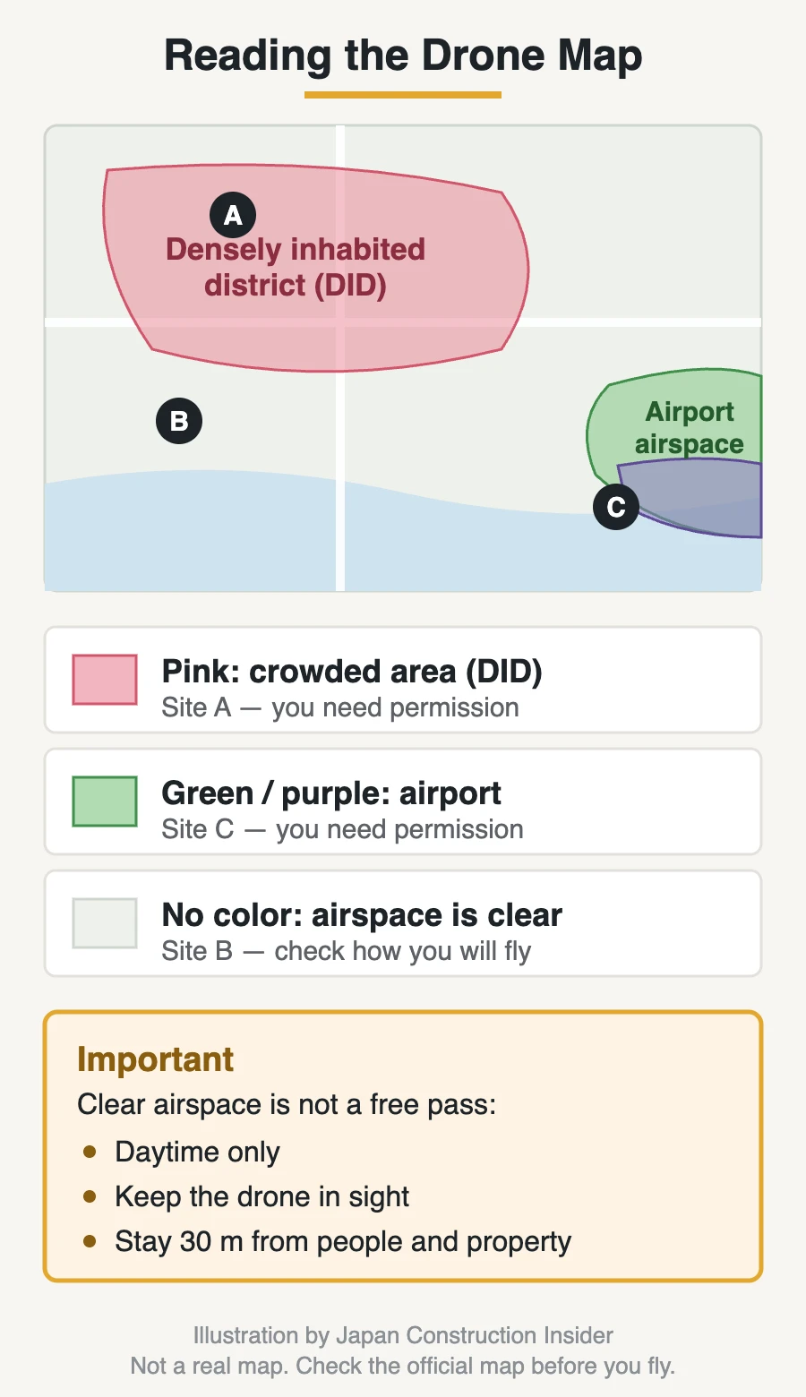
- Pink — a densely inhabited district (DID). Flying above these areas needs permission. The data comes from the national census, and the map currently shows the 2020 census areas.
- Green and purple — airspace around airports. Green marks surfaces where flying above is banned; purple marks areas where flying is banned both above and below. These also need permission.
- No color — no permission needed for the airspace itself. The rules about how you fly still apply, and so does the 150 m height limit.
Finding your site
The fastest way is the address bar. Look at the URL:
https://maps.gsi.go.jp/#10/35.675705/139.750214/&base=english...
The three numbers after the # are zoom level / latitude / longitude. Replace the latitude and longitude with your site’s coordinates (you can copy them from any map app), press Enter, and the map jumps there. Use a zoom level of 15 or so to see the site clearly.
You can also use the search box at the top left, though it works best with Japanese place names.
What to do with what you see
- Site is in a colored area → you’ll need flight permission. Apply through DIPS, the government’s online system, before the flight.
- Site has no color → you may still need approval for how you fly.
Important: even in “clear” airspace, these rules still apply
A site with no color on the map only means the airspace is clear. It does not mean you can fly however you like. Unless you have separate approval, you must:
- Fly in the daytime — night flying needs approval
- Keep the drone within your sight at all times — no flying by camera view alone
- Stay 30 m or more from people and property that aren’t part of your operation
- Stay below 150 m
On a construction site, daytime, line of sight, and the 30 m rule are the three that matter most. A site is full of people, machines, and neighboring buildings, so in practice many site flights need approval even when the map shows no color. Please don’t skip this step because the map looked clear.
One caution, straight from the map’s own notice: this data can contain errors, and airport boundaries can change due to construction work. Near a boundary, check with the airport operator, and confirm the current rules on the MLIT website before you fly.
Source: Geospatial Information Authority of Japan, GSI Maps (population concentration areas: Statistics Bureau of Japan) / MLIT, Flight Rules for Unmanned Aircraft
What It’s Really Like on Site
The cheap drone and the factory roof
Let me tell you how I learned my first lesson.
I wanted to try aerial photos on my site, so I bought a drone for about 10,000 yen to test the idea. It flew fine indoors. Outside, the wind picked up — nothing dramatic, just a breeze — and the drone stopped doing what I told it to. It slid sideways, crossed the site boundary, and came down on the roof of the factory next door.
Going next door to explain what had happened, and to ask for my drone back, was not my proudest moment as a site supervisor.
Here’s what I took away from it. A cheap drone and a survey drone look similar, but they are not the same machine. Drones made for work hold their position using satellite positioning and sensors, so they stay put when the wind pushes them. A toy drone doesn’t have much of that. On an open construction site, with wind coming off the buildings, that difference decides whether your drone comes home.
If you’re flying anywhere near other people’s property, please don’t test your luck with the cheapest machine you can find. I did, and I got lucky that it landed on a roof and not on someone’s car — or someone.
The power lines I flew too close to
The other one still makes me uncomfortable to think about.
There were high-voltage power lines running near the site. I knew they were there — you can see them from the ground — but from where I was standing, with the drone up in the air, it was much harder to judge how close it actually was. At one point it passed near the lines, and I brought it straight back down.
Nothing happened. But “nothing happened” isn’t the same as “it was safe.”
Two things I do differently now:
- Walk the site first and look up. Power lines, temporary lighting, crane jibs, antennas. Decide before takeoff where the drone will and won’t go.
- Watch from the side, not from underneath. Standing below the drone makes it almost impossible to judge distance. Standing off to one side, you can actually see the gap.
A few other things the site teaches you
- Wind is stronger up there. It can be calm at ground level and rough at roof height, especially between tall buildings.
- Tell people first. The crew, the neighbors, and anyone whose property you’ll be near. A drone overhead makes people nervous if they don’t know why it’s there.
- Watch the battery, and land early. Flying until the low-battery warning is not a plan.
- Decide where you’ll land if something goes wrong. Pick the spot before you take off, not while the drone is drifting.
If You Want to Fly in Japan
First, a rule that isn’t about flying
This one surprises a lot of visitors. In Japan, the radio transmitter inside your drone must be approved under Japan’s Radio Act. Approved equipment carries a mark called giteki (the technical conformity mark).
A drone bought overseas may not have it — and using unapproved radio equipment here can break the law, even if your flight itself follows every aviation rule. Some models are sold in Japan-specific versions for exactly this reason. So before you bring a drone into Japan, check whether your model is approved for use here.
The steps, in order
- Check the radio approval (the giteki mark), as above.
- Register the aircraft if it weighs 100 g or more. You do this in DIPS, the government’s online system. Identity can be confirmed with a passport, so overseas applicants can register.
- Fit Remote ID and display the registration number on the airframe.
- Check the map for DID and airport airspace (chapter 4).
- Apply for permission through DIPS if your airspace, or the way you plan to fly, needs it. Apply well before the flight — this is not a same-day process.
- Get insurance. It isn’t required by law, but most operators here carry liability insurance, and many sites will ask about it.
Do you need a license?
For most work, no. A national license (Class 1 or Class 2) makes approvals simpler and opens up the hardest category of flight, but you can fly for work with permission and no license.
If you do want one, be aware that the training and exams are run in Japanese. Private courses like the DPA certification I took are also in Japanese. If your Japanese isn’t strong yet, teaming up with a licensed local pilot is often the practical route.
If you’re joining a construction company here
Good news: the paperwork usually isn’t yours. On the sites I know, the company handles registration and flight permission, and a trained member of the team flies. What’s expected of you is more practical — knowing where the drone will fly, keeping people clear, and speaking up when the wind picks up.
Rules in this area change fairly often. Everything here was checked on September 20, 2026, so please confirm the current rules on the MLIT and DIPS websites before you fly.
Source: MLIT, Unmanned Aircraft Registration Portal and Flight Rules for Unmanned Aircraft / Ministry of Internal Affairs and Communications (Radio Act, technical conformity mark)
FAQ
Can I bring my drone to Japan as a tourist?
You can bring it, but you can’t just fly it. Two things have to be in order: the drone’s radio transmitter must be approved for use in Japan (the giteki mark), and any drone weighing 100 g or more must be registered before it flies outdoors. Many popular tourist spots also sit inside restricted airspace, so check the map first.
Do I need a license to fly a drone in Japan?
For most flights, no. Japan has national pilot certificates (Class 1 and Class 2), but they aren’t required for ordinary work — you apply for permission for the flight instead. A license mainly reduces paperwork and allows the most difficult category of flight.
How do I know if I need permission?
Check two things. First, the airspace: open the government’s map and see whether your spot is colored as a densely inhabited district or as airport airspace. Second, how you plan to fly: at night, out of sight, or closer than 30 m to people and property all need approval. Applications go through the DIPS website.
Are drones common on Japanese construction sites?
They’re a normal tool, but how often they fly depends on the site. Large sites may fly daily, sometimes with drones set to take off on a schedule by themselves. On a small building site, you can see the whole job from the ground, so flights are much less frequent.
What’s the difference between a cheap drone and a survey drone?
Mostly, how well it holds its position. Drones built for work use satellite positioning and sensors to stay where you put them, and they handle wind far better. I learned this the hard way when a cheap drone drifted onto the roof of the factory next door.
Does a drone replace surveyors?
No. A drone collects data faster and reaches places people shouldn’t have to climb to, but someone still plans the flight, sets the ground reference points, checks the results, and decides what they mean.
Summary
Here’s the short version of what we covered.
- Drones are a normal tool on Japanese sites — progress photos, earthwork surveys, roof and high-place checks, and safety planning. They don’t replace people; they save climbs and give you views you couldn’t get otherwise.
- Drone surveying turns overlapping photos into a 3D model of the ground, which is used for earthwork volumes and for feeding the machines. Japan’s national program, i-Construction 2.0, is pushing this further, with a target of saving at least 30% of the labor, or improving productivity by 1.5 times, by fiscal year 2040.
- Japan’s rules start at 100 g, not 250 g. Register the aircraft, fit Remote ID, and check both the airspace and the way you plan to fly.
- A free government map shows the restricted airspace — pink for densely inhabited districts, green and purple for airport airspace. But clear airspace still doesn’t allow night flights, flying out of sight, or coming within 30 m of people and property.
- On site, the real risks are wind, power lines, and overconfidence. I’ve got a cheap drone on a factory roof to prove it.
If you’re thinking about flying in Japan — as a visitor, or as someone working here — start with the radio approval and the registration, then the map, then the flight itself. It’s more paperwork than some countries, but the process is clear once you’ve done it once.
And if you have questions about drones on Japanese sites, or anything else about working here, feel free to reach out anytime!
Read next: Japanese Construction Workwear: From Baggy Pants to Fan Jackets, and Why | ICT Construction in Japan: What It Saves, and What It Costs
Another one Japan did not invent: Construction Robots in Japan: Why Rivals Stopped Competing — same honest question asked of construction robots.